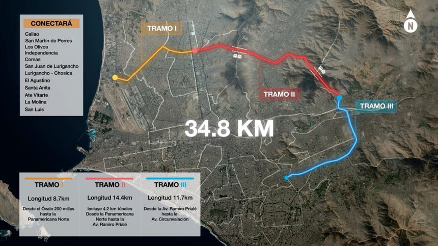
The landscape of Lima and Callao, two of the most densely populated and traffic-congested metropolitan areas in Latin America, is poised for a radical transformation. At the heart of this change is the Anillo Vial Periférico (Peripheral Ring Road), a massive infrastructure project designed to bridge critical gaps in the city’s connectivity. With an estimated length of 34.8 kilometers and a design that integrates sophisticated engineering with urban planning, the project aims to slash travel times, reduce congestion, and link key economic hubs across 12 districts.
As the project moves from the planning phase into the tangible reality of land acquisition and construction preparation, it stands as a testament to the scale of modern urban engineering. Recently, Christy García-Godos, the Institutional Relations Manager for the project, confirmed that the long-awaited construction of the first phase is scheduled to commence in the first half of 2027, marking a turning point for commuters in the Peruvian capital.
The Scope of the Megaproject: A Technical Overview
The Anillo Vial Periférico is not merely a road; it is a comprehensive transportation artery designed to alleviate the chronic gridlock that plagues the Lima-Callao metropolitan area. The project spans 34.8 kilometers and features a sophisticated configuration: a primary trunk road with three lanes in each direction, operated under a toll system, running parallel to free-access, two-lane side roads.
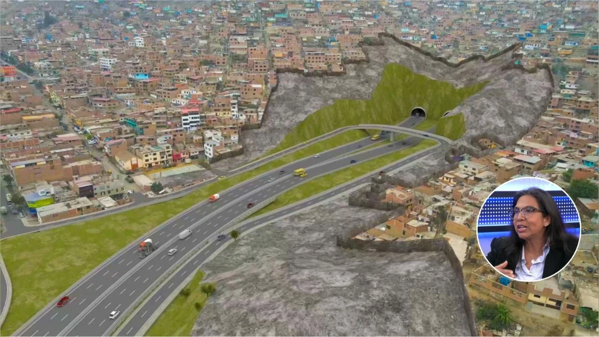
One of the most complex aspects of the construction involves the creation of 4 kilometers of tunnels, which will be carved through the challenging geological terrain of the Mangomarca and Amancaes hills. This feat of engineering is essential to maintaining the fluidity of the route as it cuts through the hilly topography of the eastern districts.
The project is designed to integrate seamlessly with Lima’s existing and future mass transit network. It will provide direct links to:
- Metro de Lima: Lines 1 and 2, and the planned branch of Line 4.
- Mass Transit Systems: The Metropolitano BRT system.
- Logistics Hubs: The Jorge Chávez International Airport and the Port of Callao.
- Future Connections: The upcoming San Juan de Lurigancho – San Martín de Porres cable car system.
Chronology and Phased Implementation
The execution of the Anillo Vial Periférico will be conducted in three distinct stages, reflecting the complexity of the terrain and the scale of the necessary land expropriations.
Phase 1: The Foundation (Starting 2027)
The first segment, covering 8.7 kilometers, will connect the Canta Callao oval to the intersection of Naranjal and the Panamericana Norte. This phase is considered the most "advanced" in terms of administrative preparation. Construction here is slated to begin in the first half of 2027, with an estimated duration of 38 months.
Phase 2: The Logistics and Tunneling Phase
The second segment is the most challenging, covering 15.1 kilometers from Naranjal to the vicinity of Ramiro Prialé. This section includes the critical 4-kilometer tunnel system. Because of the geological risks and the need for specialized construction techniques, this phase requires extensive preparatory work. The construction period for this segment is estimated at 61 months.
Phase 3: The Southern Corridor
The final segment spans 11 kilometers, stretching from the Ramiro Prialé highway to the Circunvalación avenue, passing through the Separadora Industrial and reaching San Luis. This segment is expected to take 42 months to complete, with construction beginning approximately six months after the commencement of the first phase.
Addressing the Human and Legal Cost: The Land Expropriation Process
A project of this magnitude inevitably impacts existing infrastructure and private property. According to Christy García-Godos, the project has identified a total of 5,023 properties required for the construction corridor.
It is vital to distinguish between a "property" (predio) and a "household," as a single property may contain multiple families. This distinction underscores the social sensitivity of the process. Since the Ministry of Transport and Communications (MTC) initiated the identification and liberation process in 2022, 813 properties have been successfully cleared, compensated, and transferred.
The Mechanism of Land Acquisition
The responsibility for this massive logistical undertaking is shared between the public and private sectors:
- The Concessionaire: Responsible for the technical and legal management of land acquisition.
- ProInversión: The final authority responsible for the oversight and final approval of the expropriation processes.
For properties involving vulnerable populations, the project has established specific protocols. These include tailored compensation programs designed to support residents and businesses affected by the displacement, ensuring that the development of infrastructure does not come at an unfair cost to the city’s most vulnerable citizens.
Official Responses and Stakeholder Expectations
During her appearance on the program Economía para Todos (Economy for Everyone) on RPP, García-Godos emphasized that the timeline is dictated by the strict requirements of the concession contract. "The first segment should, according to the concession contract, begin construction in the first half of next year," she noted.
The project is widely viewed as a necessity for the economic competitiveness of Lima. By bypassing the congested city center, the ring road is expected to significantly reduce travel times for heavy cargo heading to the port and airport, as well as for daily commuters. However, the success of the project hinges on the continued efficiency of the land liberation process, which remains the primary bottleneck for the construction teams.
Implications: A New Era for Lima’s Urban Planning
The implications of the Anillo Vial Periférico extend far beyond simple traffic reduction. By creating a modern, high-speed loop around the metropolitan core, the project is expected to:
- Economic Integration: The connection between the industrial sectors of the north and the commercial hubs of the east and south will lower logistics costs for businesses operating in the capital.
- Urban Decentralization: By improving access to previously difficult-to-reach areas, the road may encourage further urban development and investment in the districts of Comas, Lurigancho-Chosica, and Ate.
- Environmental Impact: While the construction phase will undoubtedly bring dust and noise, the long-term goal is to reduce the carbon footprint of Lima’s transport sector by decreasing the time vehicles spend idling in traffic jams.
Challenges Ahead
Despite the optimism, the project faces ongoing scrutiny regarding its environmental impact, the fairness of the compensation for expropriated families, and the potential disruption during the years of construction. The government and the concessionaires are under pressure to maintain transparency in the land acquisition process to prevent the social unrest that has historically stalled similar projects in Peru.
Conclusion
The Anillo Vial Periférico represents a monumental shift in how Lima and Callao manage the pressures of a growing metropolis. With the target date for the first segment fast approaching, the city is entering a critical period of preparation. If the timeline holds, and the complex process of land acquisition continues to move forward in coordination with the MTC and ProInversión, the project will fundamentally alter the geography of the capital.
For the residents of the 12 districts affected—ranging from the industrial hubs of Callao to the expanding neighborhoods of Ate and La Molina—the promise of a 30-minute transit time across the city is a beacon of hope. However, the path to completion is paved with complex engineering, difficult social negotiations, and a decade of construction. As the machines prepare to mobilize in 2027, the focus remains on whether the project can deliver on its promise of a more connected, efficient, and modern Lima.