Introduction: A Proactive Defense Against Geological Hazards
As the specter of the El Niño Phenomenon (FEN) 2026-2027 looms over Peru, the Instituto Geológico, Minero y Metalúrgico (INGEMMET) has launched an aggressive, data-driven initiative to safeguard vulnerable populations. Through its Directorate of Environmental Geology and Geological Risk (DGAR), INGEMMET has deployed seven specialized brigades across the most at-risk regions of the country. This mission, running from August 13 to September 17, represents a critical intersection of scientific rigor and disaster risk management, aiming to provide local, regional, and national authorities with the precise technical intelligence required to mitigate the potentially devastating impact of extreme weather events.
Main Facts: The Scope of the Mission
The current deployment is not a localized effort but a strategic national operation. The seven brigades have been distributed to cover the regions most historically susceptible to the geological instability triggered by intense rainfall associated with El Niño:
- Tumbes: 1 brigade
- Piura: 1 brigade
- La Libertad: 1 brigade
- Áncash: 2 brigades
- Lima Provinces: 2 brigades
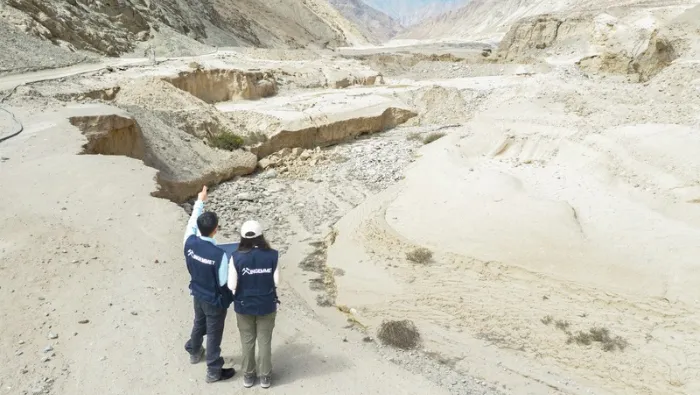
These teams are tasked with identifying and re-evaluating "critical zones"—sectors where geological and geomorphological conditions, combined with historical disaster data, signal a high probability of future hazard activation. The focus remains on identifying potential mass movements, including landslides, rockfalls, debris flows (huaicos), and catastrophic river erosion. By utilizing high-precision drone technology and rigorous inventory methodologies, the teams are performing a granular analysis of the landscape that is vital for informed decision-making.
Chronology of the Operational Deployment
The operational timeline was designed to maximize the window of preparation before the typical peak of the rainy season.
- August 13, 2026: Commencement of field operations. Brigades were mobilized to their respective regional hubs, initiating contact with local government agencies.
- August 20, 2026: High-level coordination meetings with the Center for Regional Emergency Operations (COER) in Piura, marking a critical milestone in the synchronization of state resources.
- Mid-August to Mid-September 2026: The active field assessment phase. During this time, teams are conducting site inspections, interviewing local stakeholders, and updating digital repositories.
- September 17, 2026: The scheduled conclusion of field data collection, followed by a transition to the technical reporting phase.
This timeline is deliberately compressed to ensure that the findings are delivered to municipal and regional authorities while there is still a window of opportunity to execute preventative infrastructure works.
Supporting Data: The Weight of Historical Evidence
INGEMMET’s current intervention is built upon a foundation of extensive, long-term research. The agency is not starting from a blank slate; it currently manages a national database comprising 2,186 designated critical zones and over 36,000 recorded geological hazards across Peruvian territory.
The current mission serves as an essential update to these records. By revisiting sites that were previously assessed during the 2017 Coastal Niño and the 2023-2024 El Niño, INGEMMET researchers are measuring the "evolution" of these hazards. The environment is dynamic; soil saturation, seismic shifts, and human land-use changes can transform a stable slope into a high-risk zone within a few years. Consequently, these teams are not just verifying past data—they are identifying newly emerged zones of "High" and "Very High" risk that were not present in previous cycles. This longitudinal data approach allows the government to track how specific geological sites respond to repeated stress, providing a clearer picture of regional vulnerability.
Official Responses and Inter-Institutional Synergy
The success of this initiative relies on a multi-level government approach. Recognizing that geological science is only as effective as the policy it informs, INGEMMET’s brigades have prioritized meetings with Regional Governments, the COER, and municipal authorities.

For instance, the COER of the La Libertad Regional Government has already integrated the findings from the initial site visits, covering provinces such as Chepén, Pacasmayo, Ascope, Gran Chimú, Otuzco, Julcán, Trujillo, and Virú. By presenting the technical plan directly to these bodies, INGEMMET ensures that the "Technical-Scientific Special Reports" that will follow the mission are not merely filed away, but used as the primary basis for allocating regional budgets for disaster risk reduction.
This collaborative model bridges the gap between the scientist in the field and the mayor in the office. It ensures that when an INGEMMET report identifies a slope as a "High Risk" zone, the local government has the necessary documentation to initiate evacuation planning or, where possible, construct containment barriers and drainage systems.
Implications for Public Safety and Future Resilience
The implications of this mission extend far beyond the immediate 2026-2027 season. By providing a transparent and updated evidence base, INGEMMET is fundamentally shifting the culture of disaster response in Peru from reactive to proactive.
1. Informed Policy Making
The reports generated will serve as "decision-making tools." Authorities will receive specific recommendations on land use, population displacement, and infrastructure reinforcement. This reduces the ambiguity that often plagues local disaster management during crises.
2. Public Transparency via "Perú en Alerta"
Democratizing access to geological data is a key component of this strategy. Through the Perú en Alerta platform, INGEMMET provides citizens with the ability to check the hazard status of their own communities. This transparency empowers the public to hold local officials accountable for land management and safety, while also fostering a better-informed citizenry that understands the risks inherent in their environment.
3. Long-term Climate Adaptation
As climate change continues to increase the frequency and intensity of extreme weather events, the methodologies pioneered by INGEMMET serve as a template for other nations in the Andean region. The integration of drone-based aerial surveillance with traditional geological fieldwork allows for a level of detail that was previously impossible. This technological leap ensures that the country is better prepared to face the unpredictable nature of the Pacific climate cycles.
Conclusion: A Scientific Imperative
The work being conducted by the INGEMMET brigades is a testament to the vital role of applied earth sciences in modern governance. By mapping the dangers beneath our feet, the agency provides the essential baseline for protecting lives and livelihoods. While no amount of scientific study can eliminate the natural threat posed by the El Niño phenomenon, the rigorous, objective, and timely information gathered by these specialists provides the most effective shield currently available.
As the September 17 deadline approaches, the data being compiled will form the bedrock of Peru’s strategy for the coming years, ensuring that when the rains begin, the nation is not merely reacting to the storm, but standing on a foundation of scientific foresight and institutional preparedness.