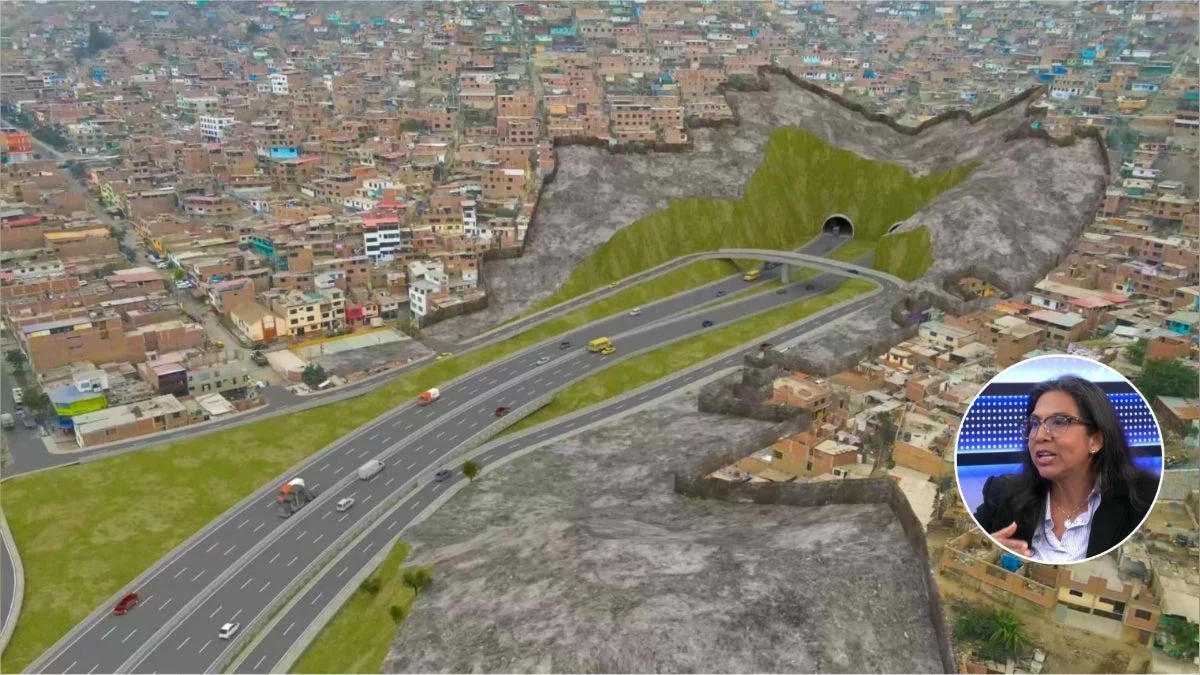
The landscape of urban mobility in Lima and Callao is on the cusp of a historic transformation. The Anillo Vial Periférico, a massive infrastructure project spanning 34.8 kilometers, is moving steadily through its critical pre-construction phase. Designed to alleviate the chronic traffic congestion that plagues the Peruvian capital, this project represents one of the most ambitious engineering undertakings in the history of the region.
With a design that includes 4 kilometers of tunnels and a complex network of multi-lane highways, the project is slated to connect 11 districts across Lima and one within the Callao province. As officials move closer to breaking ground, the focus has shifted toward the massive logistical challenge of land acquisition, a prerequisite for the project’s success.
Main Facts: The Scope of the Megaproject
The Anillo Vial Periférico is not merely a highway; it is a high-speed orbital corridor intended to redefine how commuters move through the metropolitan area. The primary artery will feature three lanes in each direction, supplemented by toll-free frontage roads to ensure that local traffic remains segregated from high-speed through-traffic.
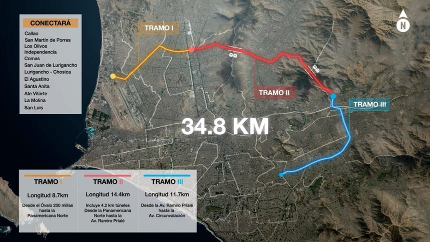
The project is structured into three distinct segments, each with unique technical requirements:
- Segment 1: Spanning 8.7 kilometers, this section will link the Canta Callao oval with the junction of Naranjal and the Panamericana Norte. It primarily impacts the districts of Los Olivos, San Martín de Porres, Independencia, and Callao.
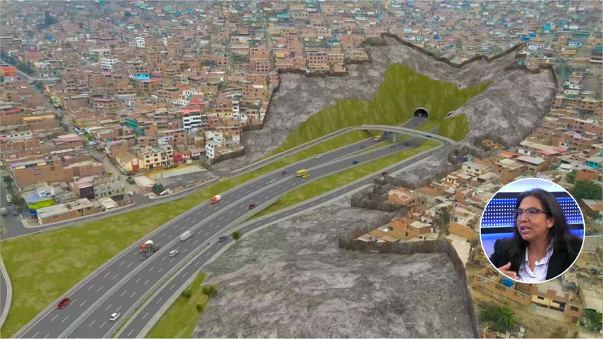
- Segment 2: This is the most complex phase, covering 15.1 kilometers from Naranjal to the vicinity of Ramiro Prialé Avenue. It features the signature 4-kilometer tunnel system that will pierce through the Mangomarca and Amancaes hills. This section traverses Independencia, Comas, San Juan de Lurigancho, and Lurigancho-Chosica.
- Segment 3: Stretching 11 kilometers from Ramiro Prialé to Circunvalación Avenue, this segment passes through the industrial and residential heart of the city, including El Agustino, Ate, Santa Anita, La Molina, and San Luis.
Beyond its physical footprint, the project is designed to act as an "intermodal backbone." It will integrate with the existing Lima Metro Lines 1 and 2, the future branch of Line 4, the Metropolitano bus rapid transit system, the Jorge Chávez International Airport, the Port of Callao, and the planned San Juan de Lurigancho-San Martín de Porres cable car system.
Chronology: From Planning to Execution
The journey of the Anillo Vial Periférico has been one of rigorous bureaucratic and technical preparation. According to Christy García-Godos, manager of Institutional Relations for the project, the timeline for the next phase is clearly defined:
- 2022: The Ministry of Transport and Communications (MTC) initiated the formal identification and liberation of properties required for the right-of-way.
- Early 2027 (First Semester): Construction is scheduled to commence on the first segment. This section is prioritized because the land liberation process is currently in its most advanced stage.
- Mid-2027: Roughly six months after the first segment begins, work is expected to initiate on the third segment.
- Long-term Phase: The second segment—the most technologically challenging due to the tunnel construction—will begin after significant progress is made in the other sectors, allowing for specialized geological and safety work to proceed without impeding the progress of the entire corridor.
Supporting Data: The Logistics of Land Liberation
A project of this magnitude inevitably impacts private property, and the scale of the "land liberation" process is significant. Officials have identified 5,023 properties that must be acquired to clear the path for construction.
It is important to note that the number of properties does not equate to a simple count of households; a single property may contain multiple families, necessitating a nuanced social approach. As of the latest reports, 813 properties (both public and private) have been fully processed—meaning they have been paid for and legally transferred. The remaining 4,941 properties are currently undergoing technical and legal evaluations to determine fair compensation and transfer timelines.
The government, via ProInversión, and the private concessionaire are collaborating closely to ensure that the compensation process is transparent. For areas involving vulnerable populations, specific social programs have been designed to provide additional support, ensuring that the development of the city does not come at the cost of those least able to relocate.
Official Responses and Construction Timelines
The project is moving forward under a strict concession agreement. When asked about the potential for delays, project representatives emphasized the importance of the technical sequencing.
"The first segment should, according to the concession contract, begin construction in the first half of next year," noted García-Godos during an interview. However, she was quick to clarify that the construction timelines vary based on the engineering complexity of each section:
- Segment 1: 38 months of estimated construction.
- Segment 2: 61 months, reflecting the extreme engineering requirements of the tunneling process.
- Segment 3: 42 months of estimated construction.
The division of labor between the public and private sectors is clear: the concessionaire handles the granular management of the land acquisition, while the final oversight and approval rests with ProInversión. This dual-layered verification process is intended to prevent the common pitfalls of corruption and mismanagement that have historically plagued large-scale infrastructure projects in the region.
The Implications: A New Era for Lima’s Traffic
The implications of the Anillo Vial Periférico extend far beyond simple convenience. Currently, transit between major hubs like Ate and Callao can take hours, stifling economic productivity and significantly diminishing the quality of life for millions of residents. By creating a high-speed peripheral loop, the project is expected to slash travel times, with estimates suggesting a commute between key nodes could be reduced to just 30 minutes.
Economic Impact
The economic benefits of the project are twofold. First, the construction phase will generate thousands of direct and indirect jobs, providing a stimulus to the local economy. Second, once completed, the improved connectivity will lower logistics costs for businesses operating in and around the Port of Callao and the airport, effectively making Lima a more competitive global trade hub.
Urban Planning and Sustainability
By diverting heavy transit vehicles away from the dense city center, the Anillo Vial Periférico will help reduce localized air pollution and noise in residential zones. Furthermore, the integration with existing mass transit systems like the Metro and the Metropolitano encourages a shift toward public transport, which is essential for the long-term sustainability of a city as large as Lima.
Challenges Ahead
Despite the clear benefits, the project faces challenges. The primary obstacle remains the complexity of the tunneling in the second segment, which requires precise geological mapping and advanced safety protocols to navigate the hills of Mangomarca and Amancaes. Additionally, the social impact of relocating over 5,000 properties requires sensitive handling to avoid public backlash and ensure that the process remains equitable.
Conclusion
The Anillo Vial Periférico represents a paradigm shift for Lima and Callao. While the road ahead—both literal and metaphorical—is complex, the project is firmly in the execution phase. By prioritizing the liberation of land and establishing a logical, segmented construction timeline, the project is positioning itself to deliver a long-awaited solution to the city’s gridlock. As 2027 approaches, the residents of these 12 districts look toward a future where the urban landscape is defined not by hours spent in traffic, but by the efficiency of a world-class infrastructure network.