In a concerted effort to mitigate the catastrophic impact of natural phenomena, the Peruvian Ministry of Housing, Construction, and Sanitation (MVCS) has successfully completed a series of critical preventive interventions across the Ancash region. These operations, focused on the cleaning and desilting of riverbeds and ravines, represent a strategic shift from reactive disaster management to proactive risk reduction. By targeting vulnerable zones before the onset of the rainy season, the government aims to safeguard the lives and livelihoods of thousands of citizens living in high-risk areas.
The Scope of Recent Interventions: Protecting Vulnerable Populations
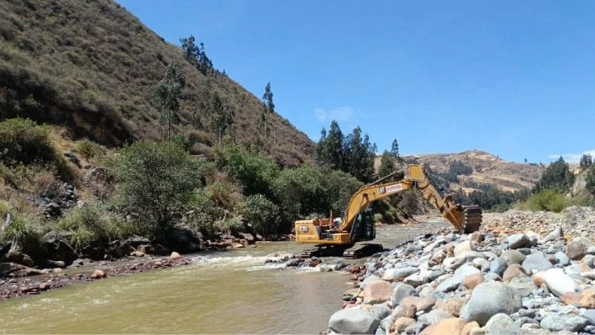
During the month of August, the MVCS, operating through its specialized Programa Nuestras Ciudades (PNC), executed a comprehensive series of interventions across the Ancash department. These works focused on 2.3 kilometers of high-risk geography, specifically within the districts of Huaraz, Recuay, Yungay, and Shupluy.
The primary objective of these engineering efforts was to restore the natural capacity of waterways. Over time, riverbeds and ravines accumulate sediment, debris, and refuse, which significantly restricts water flow and increases the risk of overflow during periods of intense rainfall. By removing these obstructions, the Ministry has effectively lowered the probability of flash floods and huaicos (debris flows), which have historically caused significant damage to infrastructure and residential areas in the Andean highlands.
The reach of these preventive measures is substantial, directly benefiting more than 5,000 residents. For these communities, the clearing of these water channels provides a vital buffer against the unpredictability of the climate, ensuring that residential zones remain shielded from the destructive power of seasonal surges.

Chronology of Preventive Action: A Systematic Approach
The recent work in Huaraz, Recuay, Yungay, and Shupluy is part of a broader, year-long calendar of risk management. The timeline of these interventions underscores the Ministry’s commitment to continuous maintenance:
- Initial Phases (Early 2026): The year began with a systematic assessment of the region’s topography. Engineers and hydrologists identified specific points where sediment accumulation posed the greatest threat to urban and rural settlements.
- Emergency Response (Mid-Year): Prior to the August surge, the ministry addressed urgent situations, including significant work on the Huarmey River. Over 1.53 kilometers of the river were stabilized, providing relief to approximately 18,060 residents who had been previously identified as being at high risk of flooding.
- The August Campaign: Between July 28 and late August, the focus shifted to the 2.3-kilometer stretch across four key districts. This phase was characterized by the deployment of heavy machinery and specialized crews to tackle the most critical, high-risk bottlenecks in the local river systems.
- Ongoing Projects (Future Outlook): The ministry has already greenlit a forward-looking schedule that includes the intervention of an additional 6.21 kilometers of critical zones in the districts of Catac, Cochas, Huarmey, Samanco, and Yungay.
Supporting Data: By the Numbers
The efficacy of the PNC’s work in Ancash is best illustrated through the scale of the operations conducted thus far in 2026. The data reflects a robust commitment to infrastructure stability:
- Cumulative Reach: In the year to date, the Ministry has successfully completed 43 distinct preventive interventions.
- Total Distance Cleared: A total of 19.41 kilometers of rivers and ravines have been desilted and cleared of debris.
- Beneficiary Impact: These 43 interventions have directly enhanced the safety of 45,787 residents across the region.
- Specific Emergency Mitigation: In addition to general preventive measures, the ministry specifically intervened in 1.53 kilometers of the Huarmey River, benefiting 18,060 people.
- Transit and Connectivity: Beyond flood mitigation, the program has also prioritized connectivity, improving the transitability of 6.11 kilometers of critical zones in Huayllapampa, which serves 95 local residents who rely on these routes for daily commerce and travel.
These figures represent more than just statistics; they represent a significant reduction in the potential economic and human cost of disasters, which often cripple regional economies and displace thousands.
Official Response: The Strategy of Prevention
Minister of Housing, Construction, and Sanitation, Mauricio Arnillas, has been vocal about the necessity of this shift toward preemptive engineering. In a recent statement, the Minister emphasized the philosophical change in how the Peruvian government addresses natural hazards.

"Prevention signifies protecting families before an emergency occurs," Minister Arnillas stated. "The Ministry of Housing is working directly in the critical zones, cleaning and desilting rivers and ravines to reduce risks and ensure we are better prepared for the upcoming rains."
This proactive stance is driven by the request of local stakeholders. The projects are not decided unilaterally; they are executed at the direct request of district, provincial, and regional authorities who possess granular knowledge of the local geography and the specific needs of their constituents. This decentralized approach ensures that the Ministry’s resources are allocated where they are most needed, fostering a sense of partnership between the central government and local governance.
Implications for the Future: Building Long-term Resilience
The work being done in Ancash is part of a larger national conversation regarding the impacts of climate change in Peru. As weather patterns become more erratic, the traditional models of reactive disaster relief are becoming increasingly unsustainable. The investment in "preventive infrastructure"—the maintenance of natural drainage systems, the reinforcement of river banks, and the constant monitoring of water levels—is a cost-effective strategy that prevents the total loss of assets during the rainy season.
The Role of Technology and Planning
The integration of advanced methodologies, such as Building Information Modeling (BIM) and rigorous hydrological modeling (as evidenced by ongoing national efforts like ANIN), allows the government to simulate the impact of floods with greater accuracy. By identifying the exact volume of sediment that needs to be removed to maintain flow, the Ministry can optimize the use of heavy machinery, ensuring that every hour of work provides the maximum possible protection for the downstream communities.

Socio-Economic Stability
Beyond the physical safety of homes, these interventions provide critical economic stability. Agriculture, a primary driver of the Ancash economy, is particularly vulnerable to river overflows. By keeping the rivers contained within their channels, the Ministry is protecting not only homes but also the fertile lands and irrigation networks that sustain the regional economy. When a river overflows, the damage to crops and infrastructure can take years to recover from; by preventing that overflow, the Ministry is essentially insuring the livelihoods of thousands of smallholder farmers.
A Call for Continued Vigilance
While the 19.41 kilometers of cleared rivers represent a major achievement, the government acknowledges that the work is far from finished. The upcoming intervention of 6.21 kilometers in Catac, Cochas, Huarmey, Samanco, and Yungay is essential for safeguarding the 3,285 residents in those specific areas. The continued success of these efforts relies on a sustained budget, the availability of specialized machinery, and the ongoing collaboration between local authorities and the central government.
Conclusion
The recent work in Ancash serves as a model for how regional safety can be managed through systematic, data-driven, and collaborative efforts. By prioritizing the clearing of 2.3 kilometers of waterways in August and maintaining a momentum that has seen nearly 20 kilometers of intervention throughout the year, the Ministry of Housing has demonstrated that the most effective way to handle a disaster is to prevent it from ever happening.
As the region moves toward the next rainy season, the 5,000 residents recently shielded by these works—and the thousands more who will benefit from upcoming projects—are better positioned to weather the challenges ahead. This proactive approach to infrastructure is a testament to the fact that when government policy is aligned with the needs of the most vulnerable, it creates a resilient foundation for sustainable growth.