By Editorial Staff
In a concerted effort to fortify the resilience of high-risk regions across Peru, the Ministry of Housing, Construction, and Sanitation (MVCS) has intensified its preventive infrastructure campaign in the Huánuco region. Through the specialized Programa Nuestras Ciudades (PNC), the government has successfully intervened in over eight kilometers of critical zones, safeguarding more than 14,600 residents from the perennial threats of flooding, mudslides (huaycos), and landslides.
This initiative, which has gained momentum throughout the current year, represents a strategic shift from reactive disaster management to proactive territorial planning and structural reinforcement. By prioritizing areas historically susceptible to geological and hydrological instability, the MVCS is actively working to minimize the socio-economic impact of extreme weather events on vulnerable populations.
Main Facts: The Scope of Intervention
The scope of the MVCS’s deployment in Huánuco has been extensive and geographically diverse. Since the beginning of the year, the ministry has executed 15 distinct interventions across a wide array of districts, including Amarilis, Ambo, Cholón, Codo de Pozuzo, Huánuco, José Crespo y Castillo, Pillco Marca, and Santa María del Valle.
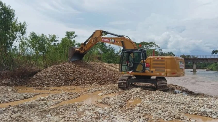
At the core of these operations is the deployment of heavy machinery—a vital resource for rural and semi-urban geography where manual labor is insufficient to alter topography or clear massive debris. The primary objective has been the comprehensive management of natural water channels, which involves the following technical procedures:
- Encauzamiento: Reshaping riverbeds to ensure water flows within safe parameters.
- Descolmatación: Removing accumulated sediment and debris that restrict water flow, which often leads to overflows during the rainy season.
- Dike Reinforcement: Strengthening the banks of rivers and streams to prevent erosion and structural failure.
These operations have covered over six kilometers of river and stream beds, directly protecting a population of 12,760 residents. By mitigating the risk of overflow, the ministry is not only protecting physical property but also ensuring the continuity of vital community infrastructure, such as roads and agricultural lands.

Chronology of Operations: From Emergency Response to Long-Term Prevention
The ministry’s presence in the region has been characterized by a dual-track strategy: immediate emergency response and planned preventive maintenance.
Phase 1: Addressing the Immediate Threat
The initial months of the year were defined by rapid deployment to high-risk zones. When heavy rains threatened to destabilize local communities, the MVCS mobilized heavy machinery to three critical emergency points: Santa María del Valle, Luyando, and Codo de Pozuzo. In these areas, technicians and operators worked on over 1.9 kilometers of river channels to prevent catastrophic flooding. These interventions provided immediate relief to 1,758 neighbors, preventing potential destruction of their homes and community assets.
Phase 2: The Tomay Kichwa Recovery
One of the most pressing incidents occurred in the district of Tomay Kichwa, within the province of Ambo. A massive landslide of mud and stones blocked local transit routes in the town of Lindero, effectively isolating residents. The MVCS responded with an emergency operation, deploying machinery to clear 0.25 kilometers of debris. This effort restored vital connectivity for 120 people, highlighting the ministry’s role in maintaining the logistical integrity of the region.
Phase 3: Current Preventive Maintenance
As of the latest reports, the ministry continues to operate in high-risk zones to prepare for upcoming seasonal shifts. Current operations are concentrated in:
- Quebrada Huamangaga (Amarilis): Focusing on drainage control.
- Quebrada San José (Mariano Dámaso Beraún, Leoncio Prado): Protecting residential sectors from sediment runoff.
- Río Huallaga (Ambo): A critical artery for the region where reinforcement is paramount.
Combined, these ongoing works cover 1.825 kilometers, shielding an additional 3,550 citizens from potential disaster.
Supporting Data: Risk Reduction Metrics
The effectiveness of these interventions is measured by the reduction in exposure to hazards. According to the data provided by the Programa Nuestras Ciudades, the ministry has utilized a metrics-driven approach to determine where its limited resources are most needed.

| Intervention Type | Kilometers Covered | Population Protected |
|---|---|---|
| Preventive Maintenance | 6.00 km | 12,760 |
| Emergency Response | 1.90 km | 1,758 |
| Urgent Clearing (Tomay Kichwa) | 0.25 km | 120 |
| Ongoing Current Operations | 1.825 km | 3,550 |
| TOTAL | 9.975 km | 18,188 |
These figures demonstrate a high efficiency in resource allocation. By focusing on critical "choke points"—areas where narrow valleys or sharp river bends increase the risk of debris accumulation—the ministry has been able to amplify the protective effect of every meter cleared.
Official Responses and Strategic Outlook
The leadership of the Ministry of Housing emphasizes that these efforts are not merely temporary fixes but part of a broader vision for the regional development of Huánuco. By investing in the stability of the terrain, the government aims to reduce the economic burden of disaster recovery, which historically has been far more costly than preventative maintenance.
The Program Coordinator for Nuestras Ciudades noted in a recent briefing that the ministry’s strategy is inherently linked to regional land-use planning. "We are not just moving dirt; we are securing the safety of the families that define the future of this region," the official stated.
Looking ahead, the ministry has announced an ambitious roadmap. The PNC has earmarked an additional 11.248 kilometers of critical zones for intervention. These upcoming projects will focus on the districts of Amarilis, Churubamba, Codo de Pozuzo, Huánuco, José Crespo y Castillo, Pillco Marca, and San Rafael. It is estimated that these upcoming interventions will offer added security to another 8,360 residents, further closing the gap between current risk levels and safe habitation standards.
Implications: The Path Toward Sustainable Safety
The ongoing work in Huánuco serves as a template for how the Peruvian government intends to handle the increasing volatility of the Andean climate. With climate change altering weather patterns, the intensity and frequency of landslides are expected to rise.
Economic Implications
For the local economy, these infrastructure projects provide long-term stability. Farmers who operate near riverbeds are less likely to lose their harvests to flooding, and small businesses in the urban centers of Huánuco face less uncertainty regarding infrastructure damage. When transit routes remain open, commerce flows uninterrupted, bolstering the local GDP.

Social Implications
The primary beneficiary of these interventions is the social fabric of the region. Displacement caused by natural disasters is a major driver of poverty and internal migration. By stabilizing the land, the MVCS helps residents remain in their homes, preserving the cohesion of rural and urban communities.
Institutional Cooperation
The success of these projects is also a testament to the coordination between the national ministry and local district municipalities. The synergy required to move heavy machinery across difficult mountainous terrain requires localized knowledge of the land, which is provided by municipal governments, combined with the technical and financial support of the central government.
In conclusion, the Ministry of Housing’s commitment to the Huánuco region is a vital step toward creating a safer, more sustainable environment for its citizens. As the program enters its next phase, the focus will remain on long-term structural integrity and the preemptive identification of hazards. By prioritizing prevention today, the government is ensuring that the communities of Huánuco can thrive in the face of tomorrow’s environmental challenges.