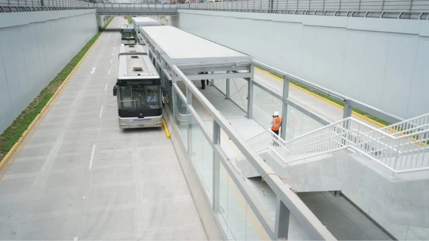
In a major milestone for urban mobility in the Peruvian capital, the Autoridad de Transporte Urbano para Lima y Callao (ATU) has officially commenced technical testing of a critical transit corridor designed to bridge the gap between two of the city’s most vital transport arteries: the Metropolitano bus rapid transit (BRT) system and the Metro Line 1. This 2.8-kilometer segregated infrastructure, spearheaded by the Municipality of Lima, represents a transformative step in reducing transit times and simplifying the daily commute for thousands of residents.
Main Facts: A New Era for Lima’s Commuters
The core of this project is a specialized, 2.8-kilometer corridor located along the Vía Expresa Grau. By establishing a direct link between the Metropolitano’s Estación Central and the Grau station of Metro Line 1, the infrastructure aims to eliminate the fragmentation that has long hindered efficient travel across the city.
The project encompasses more than just pavement; it involves the integration of four key stations and the implementation of a high-tech traffic management system. The testing phase currently underway involves the operation of standard trunk buses—without passengers—to evaluate the structural integrity of the segregated lanes and the reliability of the electronic signaling, automated station gates, and sensor networks.
By prioritizing a "segregated" design, the municipal government ensures that public transit vehicles are insulated from the chaotic congestion of Lima’s standard traffic, guaranteeing predictable travel times—a rare commodity in the city’s notoriously gridlocked streets.

Chronology of the Development
The journey to this integration has been characterized by careful engineering and inter-institutional coordination.
- Project Inception: The initiative was conceptualized as a strategic necessity to solve the "last mile" problem between the high-capacity BRT system and the heavy rail Metro line.
- Execution Phase: Construction, managed by the Municipality of Lima through the municipal agency Emape, involved a complex redesign of the Vía Expresa Grau. The project necessitated the installation of nine intelligent intersections and the construction of three intermediate stations: Abancay, Andahuaylas, and Parinacochas.
- Finalization of Civil Works: Over the past year, the physical infrastructure reached completion, shifting the focus to systems integration.
- Testing Phase (Current): As of August 2026, the ATU has begun live-testing the route. These trials serve to calibrate the synchronization between bus arrivals and automated platform systems, ensuring safety protocols are met before the public is invited to use the service.
- Future "Marcha Blanca": Following the technical validation, the authorities have committed to a "marcha blanca" (a soft-launch phase), which will introduce passengers to the system before full-scale, paid commercial operations begin.
Supporting Data and Technical Specifications
The infrastructure project is a significant capital investment for the city, totaling approximately 130 million soles. This budget covers not only the road work but also the sophisticated technology required to manage bus flows in a high-density area.
Key technical highlights include:
- Strategic Connectivity: The corridor creates a seamless transfer point at the Grau station. A unique engineering feature is the "U-turn" maneuver area designed specifically for the buses, allowing them to reverse direction efficiently and head back toward the Estación Central without disrupting the flow of the rest of the transit network.
- Safety Infrastructure: The integration of nine light-controlled intersections ensures that buses maintain priority status, significantly reducing the probability of accidents and transit delays.
- Capacity Impact: With the inclusion of the Abancay, Andahuaylas, and Parinacochas stations, the corridor serves as a high-density spine. This is particularly beneficial for commuters traveling from northern districts such as Carabayllo and Comas, who previously faced fragmented journeys when attempting to access the Grau or Aviación corridors.
Official Responses and Strategic Vision
During a recent site inspection, David Hernández, President of the ATU, joined forces with Lima’s Deputy Mayor, Renzo Reggiardo, to oversee the progress. Their presence underscored the political commitment to completing this project despite the logistical challenges inherent in working within one of the city’s most active urban centers.

"These preliminary runs are essential for the adaptation of our drivers and the rigorous testing of our technical support systems," Hernández noted. "We are committed to a seamless transition. Once the technical benchmarks are satisfied, we will move to the ‘marcha blanca’ phase, where passengers will be able to utilize the service while we monitor performance under real-world load conditions."
The project is viewed not merely as a road improvement, but as a crucial pillar in the "Master Plan for Integrated Transport." By reducing the reliance on informal, fragmented transport options, the city is moving toward a more cohesive, digitized, and efficient transit ecosystem.
Implications for the Urban Fabric of Lima
The completion of this 2.8-kilometer link carries profound implications for the socio-economic landscape of Lima.
1. Productivity and Time Management
For the average worker commuting from the northern peripheries to the central business districts, this project could shave significant time off their daily transit. In a city where workers often spend upwards of three hours a day in transit, the cumulative impact of even a 15-20 minute reduction in travel time is substantial. It represents an increase in quality of life, more time for family, and reduced stress levels for the labor force.

2. Environmental Impact
By encouraging the use of high-capacity, dedicated BRT and Metro systems, the city expects a gradual decrease in the number of smaller, less efficient, and more polluting vehicles on the road. The integration promotes a "green" shift, aligning with broader goals for urban sustainability and the reduction of the city’s carbon footprint.
3. Economic Stimulus
Infrastructure of this nature often acts as a catalyst for local development. With the addition of three new intermediate stations, the surrounding areas (Abancay, Andahuaylas, and Parinacochas) are likely to see increased foot traffic. This creates opportunities for small businesses, commercial growth, and urban revitalization around these transit nodes.
4. Setting a Precedent for Future Integration
This project serves as a "proof of concept" for the feasibility of integrating disparate transit systems in Lima. If successful, the model of segregated lanes connecting the Metropolitano to the Metro lines could be replicated in other high-traffic zones, creating a comprehensive, city-wide transit network that functions as a single, unified entity.
Conclusion
The connection of the Metropolitano to the Metro Line 1 is a testament to the ongoing evolution of Lima’s public infrastructure. While the challenges of urban planning in a metropolis as dense as Lima are immense, the focus on segregated, technology-driven corridors offers a clear path forward. As the ATU continues its testing and moves toward the official inauguration, the city stands on the threshold of a more connected future, where the barrier between the northern reaches of the capital and its central corridors is finally bridged. The residents of Lima await the "marcha blanca" with anticipation, marking the start of a more efficient and dignified way to navigate the city.